Hydroecology of Flowing Waters

Streamwater flows easily through the relatively coarse stream bottom sediments at Sugar Creek, Indiana (2-mm median grain size), delivering streamwater nitrate to sites of potential denitrification as deep as 10 - 15 cm in the streambed. Can evidence be found for denitrification throughout the entire depth of the hyporheic zone, and is this 'deeper' component of flow and reaction in this environment important for reducing downstream nitrogen loads? What is the relative importance of hydrologic (stream velocity, grain size, and hydraulic conductivity of bed sediment) and biogeochemical factors (nitrate concentration, carbon quantity and quality, and redox potential in bed sediment) that affect the rate of denitrification in the streambed?
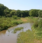
Fate of Nutrients on Floodplains of the Southeastern U.S. In the Southeastern United States, the river network contains active floodplain margins that regularly are inundated with flood water and its load of sediment and other materials during storm events. The movement of water and material onto floodplains serves to not only decrease and delay the peak discharge downstream, but also serves as an area for biogeochemical transformations. Our group is involved in examining the role of floodplains in reducing the downstream load of nutrients, specifically nitrogen species. We are currently studying floodplain dynamics in the Tangipahoa watershed that discharges into Lake Pontchartrain in Louisiana. Ongoing studies range from the centimeter to the regional scale, from examining denitrification and the flux of water in active sloughs to studying the cumulative role of floodplains within watersheds. Our work contributes to identifying the importance of riparian areas within stream networks, and the benefits provided by these regions to downstream water quality.

Woody wetland coverage (NLCD 1991) highlighting floodplain environments within the Southeastern United States (in red).

Lidar coverage of the lower Tangipahoa River near USGS gage. Research sloughs are inundated throughout the year (20% of the year on average) with water from the 2nd order Skulls Creek.

![]() U.S. Department of the Interior |
U.S. Geological Survey |
National Research Program
U.S. Department of the Interior |
U.S. Geological Survey |
National Research Program
URL: http://water.usgs.gov/nrp/jharvey/ttnsaa.html
Page Contact Information: Webmaster
Page Last Modified: Tuesday, 04-Mar-2014 11:28:16 EST
