Hydroecology of Flowing Waters
Greater integration is sought in characterizing the feedbacks between hydrologic, geomorphic, and ecological factors that influence storage, transformation, and downstream transport of solutes and particulate materials in flowing waters
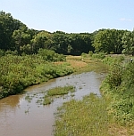
Hydroecological interactions in flowing waters have significant potential to affect water supply, water quality, and fish and wildlife habitat value of the nations aquatic ecosystems. Streams and rivers remain linked with the terrestrial landscape through repeated movement of water, solutes, and suspended materials back and forth between the active channel and floodplains. Water exchange also occurs with slowly moving subsurface waters in the hyporheic zone beneath and to the sides of the channel. These hydroecological interactions often have rapid and far-reaching effects over storage, transport, and cycling of dissolved constituents and particulates as they are transported across the landscape. In order to better understand the hydrological and ecological functions of flowing waters, the important unit of study is not the river itself but rather the considerably larger river corridor that actively exchanges water and material with the rivers active surface channel. The interplay between ecological, geomorphic, hydrologic, and biogeochemical factors will strongly influence how aquatic ecosystems, water quality, and quality of aquatic and riparian habitats respond to human disturbances and changing climate.

![]() U.S. Department of the Interior |
U.S. Geological Survey |
National Research Program
U.S. Department of the Interior |
U.S. Geological Survey |
National Research Program
URL: http://water.usgs.gov/nrp/jharvey/index.html
Page Contact Information: Webmaster
Page Last Modified: Tuesday, 04-Mar-2014 11:27:44 EST
