
Hydrologic Units
The Water Resources Council developed a hierarchial classification of
hydrologic drainage basins in the United States. Each hydrologic unit
is identified by a unique hydrologic unit code (HUC) consisting of
two to eight digits based on the four levels of classification in
the hydrologic unit system (see HUCS.TXT below). The first level of
classification consists of 21 water-resources regions as shown below.
Subsequent levels include 222 sub-regions, 352 accounting units, and
2150 cataloging units.
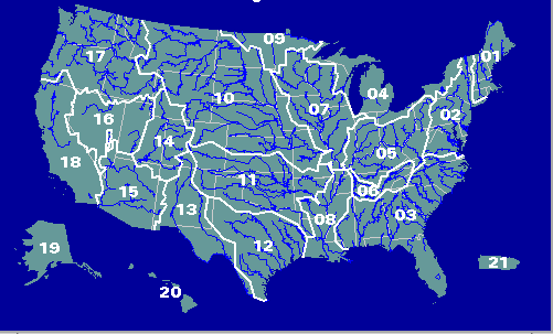
The gray lines are state lines, the blue lines are major rivers, and the white
lines are water-resources region boundary lines.
Hydrologic Unit Information Files
- HUCS.TXT gives an explanation of hydrologic
units, regions, sub-regions,
- accounting units, cataloging units, and hydrologic unit codes (HUC).
- HUC_NAME.TXT gives the full description
of all the hydrologic units.
- See the HUC_NAME.FMT file for details of the file layout.
- HUC_AREA.DAT gives the drainage area of
the hydrologic units by region,
- subregion, accounting unit, and cataloging unit.
- See the HUC_AREA.FMT file for details of the file layout.
- SREGIONS.DAT gives the names of the
hydrologic regions and subregions.
- See the SREGIONS.FMT file for details of the file layout.
- HUC 1:250k
provides digital data on hydrologic unit boundaries for the United States.
For a comprehensive discussion of hydrologic units, see:
Seaber, P.R., Kapinos, F.P., and Knapp, G.L., 1987, Hydrologic units maps: U.S. Geological Survey Water-Supply
Paper 2294, 63 p.
Return to First Page
The pathname for this page is
<water.usgs.gov/nawqa/sparrow/wrr97/geograp/geograp.html>
Last modified: Tue Apr 21 11:00:13 EDT 1998