
Stephen D. Preston, Hydrologist, U.S. Geological Survey, Baltimore, Maryland;
Richard A. Smith, Hydrologist, U.S. Geological Survey, Reston, Virginia;
Gregory E. Schwarz, Economist, U.S. Geological Survey, Reston, Virginia;
Richard B. Alexander, Hydrologist, U.S. Geological Survey, Reston, Virginia;
John W. Brakebill, Geographer, U.S. Geological Survey, Baltimore, Maryland
Proceedings of the First Federal Interagency Hydrologic Modeling Conference. Las Vegas, Nevada, April 1998
ches.pdf (file size: 3700K)
A set of spatially referenced regression models is currently being developed to relate water quality in the Chesapeake Bay to sources of nutrients in the watershed and to factors that affect the transport of nutrients to the bay. Spatially referenced regression modeling is a statistical technique that uses spatial information to provide nutrient-load predictions that are more spatially detailed than those provided by other large-scale watershed models. Two applications of the technique for the determination of total nitrogen in the Chesapeake Bay watershed are described, including the estimation of incremental (local) yields and the estimation of yields delivered to the bay. The model shows that areas that are most important to the delivery of nutrients to the bay are those that drain directly to large streams or those that are near the bay. Instream loss of nutrients is minimal in both cases, thus enhancing nutrient delivery to the bay.
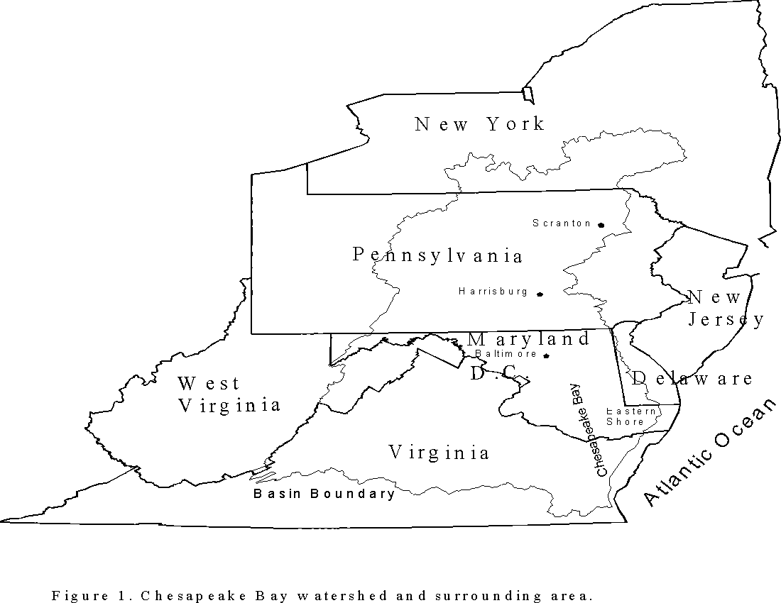
Watershed modeling is commonly considered an essential tool for evaluating the sources and controls of nutrient loading to receiving waters. Watershed models provide a framework for integrat ing the data that describe the processes and land-surface characteristics that determine the amount of nutrients transported by streams. Development of watershed models is a difficult task, however, because of the broad spatial and temporal scales that must be considered and the large amount of information that must be integrated. Funding, time constraints and available information commonly limit the amount of spatial or temporal detail that can be considered by watershed models. The Chesapeake Bay watershed is one area of the Nation where watershed modeling is being applied to evaluate nutrient loading (figure 1). Water quality and ecosystem integrity in the Chesapeake Bay have been affected by excessive nutrient loading, which has resulted in the depression of dissolved oxygen levels and the loss of submerged aquatic vegetation. These effects have impacted economically important aquatic species and have diminished the value of the bay as a recreational resource.
Watershed modeling has been an important component of the effort to understand nutrient loading to the Chesapeake Bay and to develop management strategies for controlling it. The Chesapeake Bay Program (CBP) is a multiagency taskforce that has been charged with coordinating and managing efforts to restore water quality in the bay. The CBP has developed a hydrologic and water- quality model for the Chesapeake Bay watershed using the Hydrologic Simulation Program - For tran (HSPF) modeling framework (Donigian and others, 1994). Applications of the HSPF model include (1) estimating nutrient loads from all areas of the watershed, (2) evaluating the impacts of land-use-change scenarios, and (3) evaluating the potential benefits of management practice implementation. The Chesapeake Bay HSPF model is temporally detailed in that it is based on hourly time increments of streamflow and other environmental processes, but is limited in spatial detail and is based on 86 segments that average more than 700 square miles in area.
The HSPF modeling framework is deterministic in nature and includes a substantial amount of detail in the number of processes that are considered in simulating watershed hydrology and nutrient fate and transport. The process detail included in HSPF is important for designing and evaluating nutrient management programs. The number of parameters in the model increases with the number of processes simulated, however, and determining appropriate values for those parame ters can be difficult. The current Chesapeake Bay watershed model is manually calibrated at 14 sites. Parameter values are quantified by adjusting them to fit predicted values to measured data or by adopting published values for some parameters.
To support the CBP's modeling effort, the U.S. Geological Survey (USGS) has initiated the development of a set of spatially referenced regression models. These models can be used to provide a statistical basis to watershed modeling and additional spatial detail on nutrient sources and transport processes. The method used for developing the regression models is referred to as "SPAR ROW" (SPAtially-Referenced Regressions On Watershed attributes) (Smith and others, 1997). The SPARROW methodology is designed to provide statistically based relations between stream water quality and environmental factors such as contaminant sources in the watershed, land-surface characteristics that affect contaminant delivery to streams, and instream contaminant losses. Because the regression models are linked to spatial information, predictions and subsequent analytical results can be illustrated through detailed maps that provide information about nutrient loading at multiple scales. The SPARROW methodology has been successfully applied at the national scale for estimating total nitrogen and total phosphorus loads for streams in the continental United States (Smith and others, 1997).
As an initial step in the development of SPARROW models for the Chesapeake Bay watershed, this paper describes an evaluation of the national scale model within the bay watershed. SPAR ROW regressions are currently being developed using data that are specific to the watershed, but the national model provides a useful preliminary view of nutrient loading to the bay. Specifically, this paper describes the results of two applications of the national SPARROW model for evaluating the important sources and controls of total nitrogen loads to the Chesapeake Bay.
ches.pdf (file size: 3700K)
Regression Results and Parameter Estimates
Results of model estimation for the total nitrogen national SPARROW model are summarized in table 1. Fit of the model is good with an R-squared value of 0.87 and a mean square error of 0.4544. Most of the independent variables considered were found to be significant; variables that were clearly not significant in exploratory regressions were left out of the final model. All parametric estimates of total nitrogen source parameters were found to be significant, although live stock waste production was only moderately significant (0.0632). All bootstrap estimates of total nitrogen source parameters were found to be highly significant. Three of the eight land-to-water delivery parameters were found to be significant by the parametric or bootstrap estimations. Temperature and soil permeability were inversely related to nitrogen loading possibly because higher temperature increases rates of denitrification and because higher soil permeability tends to shift nitrate transport to ground-water reservoirs. Stream density was implemented in the model in reciprocal form and is positively related to stream nitrogen loading because basins with higher stream density are expected, on average, to have shorter overland traveltimes than basins with lower stream density. Parametric estimates of instream loss parameters were highly significant for the two smaller stream-size classes. Instream loss rates are lower for larger stream sizes because larger (deeper) streams have less contact with sediment where denitrification is expected to occur.
Application of SPARROW for Spatial Nutrient Loading Analysis
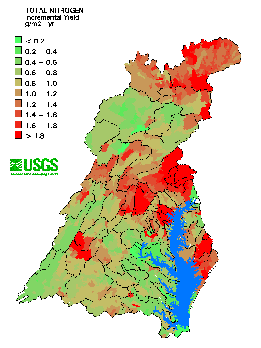
To illustrate the benefit of spatial referencing, two applications of SPARROW in the Chesapeake Bay watershed are presented (figures 2 and 3). In both cases, total nitrogen yields are calculated by dividing the predicted load by the contributing area to calculate a per unit area load. Incremental yield (figure 2) is the load generated by the area that drains directly to the reach without loads from upstream. Input to the reach is assumed to occur at the middle of the reach and instream loss is calculated over half of the length to estimate loads at the end of the reach. Incremental loads provide an indication of the relative importance of local drainage areas to nitrogen loading and provide a common basis for evaluating source areas across the entire watershed. Incremental yields provide an indication of local influences on loading, but do not account for instream losses that occur as nitrogen is transported to the Chesapeake Bay. The effects of nutrient enrichment in the bay are a major concern and land-management agencies are seeking tools for prioritizing areas for the implementation of nutrient-reduction measures. If the bay is the primary area of concern, instream loss of nutrients is important because high local loading may become insignificant over distance and with long traveltimes. To account for instream losses, "delivered yields" (figure 3) were estimated by weighting the incremental loads by the instream loss that would occur over the distance from the end of each reach to the bay. Delivered yields provide a common basis for deter mining those areas in the entire watershed that are most important to the delivery of nitrogen to the bay.
Figures 2 and 3 illustrate incremental and delivered yields by shading basin areas by yield class. Areas with high incremental yields include the New York part of the watershed, southern Pennsylvania, central Maryland, western Virginia and the lower part of the eastern shore of the bay. Causes of the high local loading in these areas vary by region. Agricultural sources (fertilizer application and livestock waste production) were important to the incremental yield in most of the areas mentioned, but especially in southern Pennsylvania, central Maryland, and the Eastern Shore. In New York, agricultural sources were important, but atmospheric deposition was the primary source of nitrogen. Point sources are important in many areas of the watershed where there are large population densities, but of the areas in figure 2 with high incremental yield, point- source loading is relatively high in the Scranton, and Harrisburg, Pa., and Baltimore, Md., areas.
Comparison of figures 2 and 3 illustrates the importance of the instream loss that occurs as nitro gen is transported to the bay. Most of the areas that had relatively high incremental (local) loading were much less important with respect to loading to the bay itself. Areas with the highest delivered nitrogen loading to the bay include northeastern and southern Pennsylvania, parts of central Maryland and parts of the lower Eastern Shore. Areas with high incremental yield and relatively low delivered yield include the New York part of the watershed and parts of central Maryland and western Virginia. The highest delivered yields are areas that drain directly to large streams or are areas of high incremental loading that are close to the bay. Areas that drain directly to large streams have less instream loss due to lower loss rates (table 1), and for that reason those areas may be more important for delivery of nitrogen to the bay. Areas near the bay may be more important for nitrogen delivery because travel distances are short and the time for instream loss is short compared to other parts of the watershed.
Dewald, T., Horn, R., Greenspun, R., Taylor, P., Manning, L., and Montalbano, A., 1985, STORET Reach Retrieval Documentation, U.S. Environmental Protection Agency. Washington, D.C.
Donigian, A.S., Bicknell, B.R., Patwardhan, A.S., Linker, L.C., and Chang, C., 1994, Chesapeake Bay Program Watershed Model Application to Calculate Bay Nutrient Loadings -- Final Facts and Recommendations. Report # EPA 903-R-94-042, U.S. Environmental Protection Agency Chesapeake Bay Program Office, Annapolis, Maryland, 283 p.
Smith, R.A., Alexander, R.B., Tasker, G.D., Price, C.V., Robinson, K.W., and White, D.A., 1993, Statistical Modeling of Water Quality in Regional Watersheds. Proceedings of Watershed `93, A National Conference on Watershed Management. Alexandria, Virginia, March 21-24, 1993, 4 p.
Smith, R.A., Schwarz, G.E., and Alexander, R.B., 1997, Regional Interpretation of Water- quality Monitoring Data. Water Resources Research, vol 33, no. 12, p. 2781-2798.
U.S. Soil Conservation Service, 1994, State Soil Geographic (STATSGO) Data Base. National Soil Survey Center. Publication number 1492, 88 p.