National Water-Quality Assessment (NAWQA) Project
 Preparing for the Third Decade
of the National Water-Quality
Assessment Program
Preparing for the Third Decade
of the National Water-Quality
Assessment Program"The need for a national water quality assessment is as important, if not more so today, as when the NAWQA program was established".
National Research Council, 2012
Restoring Monitoring for Reliable and Timely Status and Trend Assessments
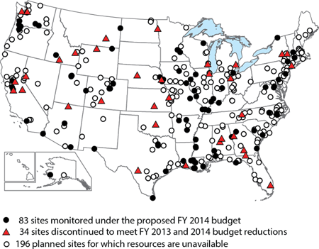
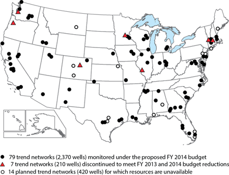
 The NAWQA program will work with State and Federal partners
to fill monitoring gaps in critical watersheds and aquifers by leveraging
available resources and collaborating with other programs to build an
expanded and sustainable national network. Monitoring approaches will
emphasize rapid feedback on changing water-quality conditions so that
managers can identify emerging problems, develop effective responses,
and evaluate the performance of management strategies. Recent
analyses of water-quality trends have shown that monitoring must be
frequent and sustained every year to reliably detect trends at the time
scales at which important changes in contaminant sources and management strategies occur. Therefore, the Science Plan emphasizes returning to yearly intensive monitoring of sites that are part of NAWQA's
surface-water-quality network, rather than a rotational approach with
many sites only periodically monitored.
The NAWQA program will work with State and Federal partners
to fill monitoring gaps in critical watersheds and aquifers by leveraging
available resources and collaborating with other programs to build an
expanded and sustainable national network. Monitoring approaches will
emphasize rapid feedback on changing water-quality conditions so that
managers can identify emerging problems, develop effective responses,
and evaluate the performance of management strategies. Recent
analyses of water-quality trends have shown that monitoring must be
frequent and sustained every year to reliably detect trends at the time
scales at which important changes in contaminant sources and management strategies occur. Therefore, the Science Plan emphasizes returning to yearly intensive monitoring of sites that are part of NAWQA's
surface-water-quality network, rather than a rotational approach with
many sites only periodically monitored.
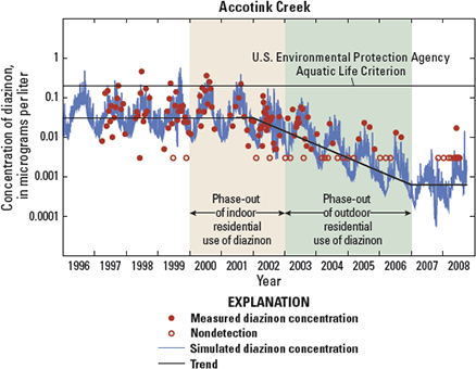
For example, monitoring data for Accotink Creek, a small urban stream near Washington, D.C., shows the importance of frequent sampling to detect and quantify the decline in stream concentrations of diazinon that occurred following the phase-out of the residential use of this insecticide that began in 2000. Being able to document the effectiveness of water-quality improvement strategies in a timely manner, as demonstrated by the every-year monitoring approach used in this example, is vital to regulatory agencies and other stakeholders in order to track the performance of management practices and determine implications for future strategies.
Providing Data and Tools to Predict Ecological Condition in Streams
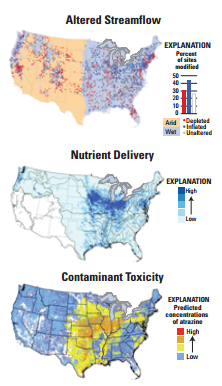 Targeted regional studies will provide resource managers with data and tools to understand and predict ecological conditions in relation to streamflow alteration and concentrations of
contaminants, nutrients, and sediment. New national and regional models of potential stressors,
such as altered streamflow, nutrient delivery, and contaminant toxicity, will provide managers
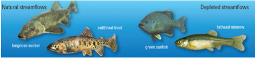
with critical information on stressors that affect ecological health. For example, Carlisle and others
(2010) showed that streams that had altered streamflows had fewer sensitive fish species than
streams characterized by more natural flow regimes.
Targeted regional studies will provide resource managers with data and tools to understand and predict ecological conditions in relation to streamflow alteration and concentrations of
contaminants, nutrients, and sediment. New national and regional models of potential stressors,
such as altered streamflow, nutrient delivery, and contaminant toxicity, will provide managers
with critical information on stressors that affect ecological health. For example, Carlisle and others
(2010) showed that streams that had altered streamflows had fewer sensitive fish species than
streams characterized by more natural flow regimes.
The regional studies will provide detailed understanding of how natural and human factors affect water quality and ecological conditions in major regions of the Nation, improve understanding of how stream quality will respond to management scenarios, and provide information that facilitates investment in the most effective restoration strategies. The first of these regional assessments is being developed in collaboration with the States and the U.S. Environmental Protection Agency's National Rivers and Streams Assessment program and will focus on stream quality in the agricultural Midwest, a region encompassing parts of 12 states (U.S. Geological Survey, 2012). Other regional studies may be done in the humid southeast, arid southwest, the Atlantic Highlands, and the Rocky Mountains.
Transforming Data and Models into Tools for Decisionmakers
 The NAWQA program's water-quality models quantitatively link
sources and management practices to water-quality benefits and effects
and can do so at multiple hydrologic scalesfrom headwater streams
to rivers flowing into estuaries, and from shallow groundwater to
deep regional aquifers. In the first two decades of NAWQA, progress
was made on the application of models to evaluate the vulnerability
of streams and groundwater to selected contaminants, such as nitrate.
Progress was also made on the application of models that link causal
factors and individual contaminants at regional and national scales.
The NAWQA program's water-quality models quantitatively link
sources and management practices to water-quality benefits and effects
and can do so at multiple hydrologic scalesfrom headwater streams
to rivers flowing into estuaries, and from shallow groundwater to
deep regional aquifers. In the first two decades of NAWQA, progress
was made on the application of models to evaluate the vulnerability
of streams and groundwater to selected contaminants, such as nitrate.
Progress was also made on the application of models that link causal
factors and individual contaminants at regional and national scales.
Findings from a national nitrate model for shallow groundwater (Nolan and Hitt, 2006) illustrate the type of information that will be further refined as data and information on sources of contaminants, management practices, and other important factors improve. Such models can be developed for other contaminantsdissolved solids, arsenic, and pesticidesand for specific regions of the country. They provide resource managers with an important starting point for evaluating which aquifers or streams are likely to have contaminant concentrations high enough to impair drinking water supplies or threaten the health of aquatic organisms. Other models examine how groundwater interacts with surface water to affect contaminant transport and the amount of time it takes water and contaminants to move from the land surface, through aquifers, and then to streams. The resulting modeling tools can be used by resource managers to evaluate changes in water quality caused by different management practices or regulatory policies and how long it will take for the effects of those changes to be observed in their watershed or aquifer.
Forecasting Future Conditions and Testing Policy Scenarios
 Forecasting and scenario-testing toolsan array of statistical and simulation modelsdeveloped by NAWQA will enable timely evaluation of current
water-quality issues as well as the possible effects of future scenarios of changing climate, land use, and management practices. Enhanced versions of the
SPARROW model, as well as other water-quality models, will be converted into
Web-accessible tools that managers can use to evaluate how water quality and
aquatic ecosystems may change in response to different scenarios.
Forecasting and scenario-testing toolsan array of statistical and simulation modelsdeveloped by NAWQA will enable timely evaluation of current
water-quality issues as well as the possible effects of future scenarios of changing climate, land use, and management practices. Enhanced versions of the
SPARROW model, as well as other water-quality models, will be converted into
Web-accessible tools that managers can use to evaluate how water quality and
aquatic ecosystems may change in response to different scenarios.
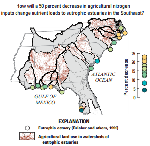
For example, SPARROW was used to predict how a 50-percent reduction in agricultural nitrogen inputs would decrease loadings to eutrophic estuaries in the eastern Gulf of Mexico and the South Atlantic Coastal Plain (Hoos and McMahon, 2009). The model showed that resulting nitrogen loads to estuaries would decrease from as little as 5 percent to a maximum of 24 percent, indicating thatin terms of total annual nitrogen loadreduction of agricultural sources alone may not markedly improve eutrophication in some of these estuaries.
Similarly, coupled groundwater quality and flow models will enable water managers to evaluate the amount of time it may take for contaminated shallow groundwater to reach production zones used as drinking water supplies.

![]() U.S. Department of the Interior | U.S. Geological Survey
U.S. Department of the Interior | U.S. Geological Survey
URL: http://water.usgs.gov/nawqa/pubs/fs-2013-3008/index.html
Page Contact Information: gs-w_nawqa_whq@usgs.gov
Page Last Modified: Wednesday, 21-Dec-2016 11:00:21 EST