24. Bar/Shelf/Island: If
channel bars, shelves, or islands are present, measure width using a tape
measure or rangefinder. Channel bars are the lowest prominent geomorphic
feature higher than, but within, the channel bed (Hupp and Oster kamp,
1985). Channel bars are typically devoid of woody vegetation and consist
of relatively coarse sand, gravel, and cobbles. Shelves are bank features
extending nearly horizontally from the flood plain to the lower limit of
persistent woody vegetation (Hupp and Osterkamp, 1985). Shelves are most
common along relatively high-gradient streams. Determine the spatially
dominant and subdominant substrates along the transect for the bars, shelves,
and islands that occur, using the codes for determining bed substrate
(number 19). Also estimate the percentage of coverage of woody and
herbaceous vegetation for the entire bar/shelf/island. If bars, shelves, or
islands are absent, record "0" for each width measurement.
25. Bank angle: A clinometer is used to measure the angle formed
by the downward-sloping bank as it meets the stream bottom. The angle is
determined directly from a clinometer placed on top of a surveyor's rod or
meter stick that is aligned parallel to the bank along the transect. The
clinometer reading is subtracted from 180 degrees to produce
the bank angle. If the height and shape of the bank are such that more
than one angle is produced, then an average of three readings is
recorded. Both left bank and right bank (facing downstream) angles are
recorded.
26. Bank height: Determine the
left and right distance from the channel bed to the top of the bank. A
surveyor's rod and hand level can be used if this distance can be measured
directly. If the bank height cannot be measured directly, then it can be
estimated. Note that the bottom of the bank is the deepest part of the
channel. At large, nonwadeable reaches, topographic maps may be useful in
determining bank height.
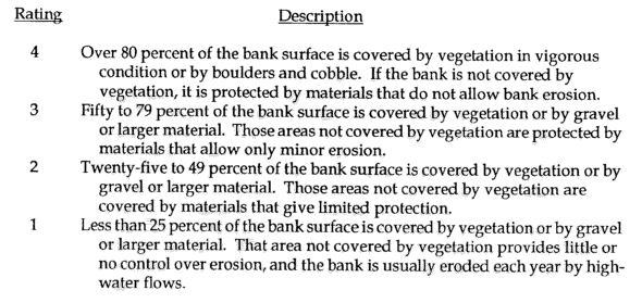
27. Bank vegetation stability: Bank vegetation stability is an
assessment of the ability of bank vegetation to resist erosion (Platts and
others, 1987). Bank vegetation stability is evaluated using a rating based
on four classes that represent percent coverage of the bank surface. The
rating includes only that part of the bank that is within 2 m of either side
of the transect, to the top of the bank.
28. Bank shape: Record the shape of the left and right banks as: