
In 1991, the U.S. Geological Survey (USGS) began to implement a full-scale National Water-Quality Assessment (NAWQA) program. The three major objectives of the NAWQA program are to provide a consistent description of current water-quality conditions for a large part of the Nation's water resources, define long-term trends in water quality, and identify, describe, and explain the major factors that affect water-quality conditions and trends. The program will produce water-quality information that will be useful to policy makers and managers at the national, State, and local levels.
The program will be implemented through 60 separate investigations of river basins and aquifer systems, called study units. These study-unit investigations will be conducted at the State and local level, and will form the foundation on which national- and regional-level assessments are based. The 60 study units are hydrologic systems that include parts of most major river basins and aquifer systems. The study-unit areas range from 1,200 to more than 65,000 square miles and include about 60 to 70 percent of the Nation's water use and population served by public water supply. In 1991, the Lower Susquehanna River basin was among the first 20 NAWQA study units selected for study under the full-scale implementation plan.
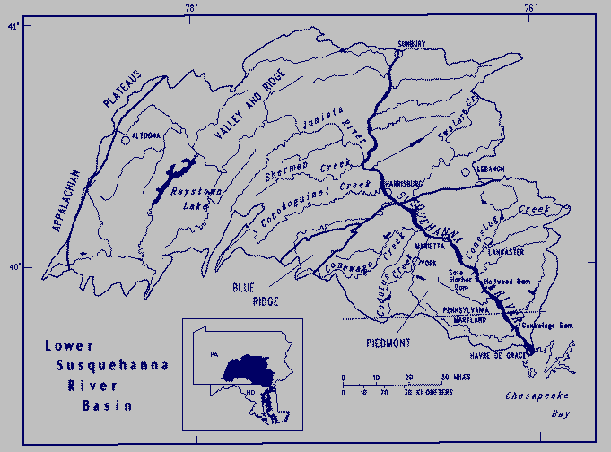
The Susquehanna River drains about 27,000 square miles of New York, Pennsylvania, and Maryland. The study unit, however, consists of 9,200 square miles in the lower Susquehanna River basin from Sunbury, Pa., downstream to the Chesapeake Bay at Havre de Grace, Md.
Three physiographic provinces are included in the lower basin, the Valley and Ridge, Piedmont, and Blue Ridge. The Valley and Ridge physiographic province is underlain by folded and faulted rocks, which are a sequence of alternating shale, sandstone, and limestone of Paleozoic age that forms steep mountains and ridges separated by valleys. The Piedmont physiographic province consists of uplands and lowlands; the uplands are underlain by crystalline rocks and the lowlands by limestone, sandstone, and shale. The Piedmont physiographic province generally has terrain that is gently rolling to hilly. Only a small part of the Blue Ridge physiographic province, which is underlain by crystalline rocks, lies within the lower basin.
The lower Susquehanna River basin has a temperate climate. The average annual temperature for the area is about 50 degrees Fahrenheit. Long periods of extreme cold or heat are infrequent. Mean annual precipitation ranges from 38 to 44 inches. Mean annual runoff ranges from about 15 inches in the southern part of the basin to 25 inches in the higher elevations. Most of the runoff results from snowmelt and rainfall in spring and early summer.
The population of the area in 1990 was about 1.85 million. Population centers are located in and around Harrisburg (52,000), Lancaster (56,000), York (42,000), Lebanon (24,800), and Altoona (52,000). Major industries in the area include agriculture, steel and paper manufacturing, and food processing.
Agriculture is the dominant land use in the study area. About 35 percent of the lower basin is used for that purpose. More than 50 percent of the basin is forested and about 15 percent is urban, residential, or other land uses.
The Susquehanna River flows through three consecutive reservoirs and dams in the lower basin--Safe Harbor, Holtwood, and Conowingo--before reaching the Chesapeake Bay. The average streamflow of the Susquehanna River at Marietta, Pa., was 23,690 million gallons per day from 1931 to 1989. The maximum streamflow during that period was 696,820 million gallons per day on June 23, 1972; the minimum streamflow was 399 million gallons per day on September 26, 1932.
Seven major tributaries drain about two-thirds of the lower basin. The Juniata River flows to the Susquehanna River from near Altoona and drains 3,400 square miles or nearly 40 percent of the lower basin. Raystown Lake, which is maintained for recreation and flood control, is in the Juniata River basin. The average streamflow of the Juniata River near its mouth was 2,770 million gallons per day from 1899 to 1989. Other major tributaries and their drainage areas west of the Susquehanna River are Sherman Creek (244 square miles), Conodoguinet Creek (506 square miles), Conewago Creek (515 square miles), and Codorus Creek (278 square miles). Major tributaries and their drainage areas east of the Susquehanna River are Swatara Creek (571 square miles) and the Conestoga River (477 square miles).
Water use in the lower basin for public supply totaled about 200 million gallons per day in 1985. About 80 percent of this withdrawal is from surface water. The lower Susquehanna River supplies water for eight municipalities that withdraw a total of nearly 20 million gallons per day; 140 million gallons per day is withdrawn from various tributaries and reservoirs.
Aquifers in the lower Susquehanna River basin are in either carbonate rocks, crystalline rocks, or sequences of sandstone and shale. Ground water from these aquifers supplied more than 180 million gallons per day in 1985 for public supply and for rural domestic, industrial, and agricultural uses. Major carbonate rock aquifers lie beneath some valleys of the Valley and Ridge physiographic province and the northernmost Piedmont. Crystalline-rock aquifers are restricted to the southernmost parts of the lower basin within the Piedmont physiographic province of Pennsylvania and Maryland. Sandstone and shale aquifers predominate along valley margins and associated ridges in the northern and western parts of the Valley and Ridge physiographic province.
Major water-quality issues in the study unit are related to:
Communication and coordination between USGS personnel and other interested scientists and water-management organizations are critical components of the NAWQA program. Each of the study-unit investigations will have a local liaison committee consisting of representatives who have water-resources responsibilities from Federal, State, and local agencies, universities, and the private sector. Specific activities of each liaison committee will include exchange of information about water-quality issues of regional and local interest; identification of sources of data and information; assistance in the design and scope of project products; and review of project planning documents and reports. The liaison committee for the Lower Susquehanna River basin study will be formed in 1991.
Leahy, P.P., Rosenshein, J.S., and Knopman, D.S., 1990, Implementation plan for the National Water-Quality Assessment program: U.S. Geological Survey Open-File Report 90-174, 10 p.
U.S. Geological Survey, 1986, National water summary 1985- Hydrologic events and surface-water resources: U.S. Geological Survey Water-Supply Paper 2300, p. 391-398.
_____, 1988, National water summary 1986-Hydrologic events and ground-water resources: U.S. Geological Survey Water-Supply Paper 2325, p. 429-436.
Information on technical reports and hydrologic data related to the NAWQA program can be obtained from:
Open-File Report 91-168
K.J. Breen, R.A. Hainly, and S.A. Hoffman, 1991
sfsiwiec@wrdmail.er.usgs.gov