If you know the 4-letter ABBREVIATION for the NAWQA study unit you want to access, the standard URL for each study unit is:
http://water.usgs.gov/lookup/get?nawqaxxxx |
A digital file of the NAWQA study unit boundaries for use in spatial data analysis is available in the National Geospatial Data Clearinghouse.
|
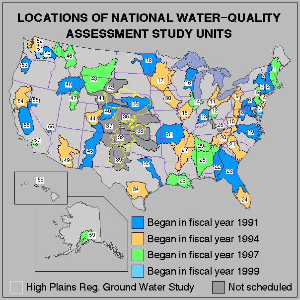
Number on map |
NAWQA Study unit name |
Starting year |
States in study unit |
Study unit abbreviation |
|
New England Coastal Basins |
1997 |
ME, MA, NH, RI |
NECB |
|
|
Connecticut, Housatonic, and Thames River Basins |
1991 |
CT, MA, NH, NY, RI, VT |
CONN |
|
|
Hudson River Basin |
1991 |
NY, CT, MA, NJ, VT |
HDSN |
|
|
4 |
Long Island-New Jersey Coastal Drainages |
1994 |
NJ, NY |
LINJ |
|
Delaware River Basin |
1997 |
PA, NY, NJ |
DELR |
|
|
Lower Susquehanna River Basin |
1991 |
PA, MD |
LSUS |
|
|
1999 |
DE, MD, VA |
DLMV |
||
|
Potomac River Basin |
1991 |
DC, MD, PA, VA, WV |
POTO |
|
|
9 |
Allegheny and Monongahela Basins |
1994 |
MD, NY, PA, WV |
ALMN |
|
Kanawha-New River Basin |
1994 |
WV, VA, NC |
KANA |
|
|
Lake Erie-Lake Saint Clair Drainage |
1994 |
IN, MI, OH, PA, NY |
LERI |
|
|
12 |
Great and Little Miami River Basins |
1997 |
OH, IN |
MIAM |
|
13 |
White River Basin |
1991 |
IN |
WHIT |
|
Upper Illinois River Basin |
1997 |
IL, WI, IN |
UIRB |
|
|
15 |
Lower Illinois River Basin |
1994 |
IL |
LIRB |
|
16 |
Western Lake Michigan Drainage |
1991 |
MI, WI |
WMIC |
|
Upper Mississippi River Basin |
1994 |
MN, WI |
UMIS |
|
|
Red River of the North Basin |
1991 |
MN, ND, SD |
REDN |
|
|
19 |
Albemarle-Pamlico Drainage |
1991 |
NC, VA |
ALBE |
|
1994 |
GA, KY, NC, SC, TN, VA |
UTEN |
||
|
21 |
Santee Basin and Coastal Drainages |
1994 |
SC, NC |
SANT |
|
Apalachicola-Chattahoochee-Flint River Basin |
1991 |
AL, FL, GA |
ACFB |
|
|
23 |
Georgia-Florida Coastal Plain |
1991 |
GA, FL |
GAFL |
|
24 |
Southern Florida |
1994 |
FL |
SOFL |
|
25 |
Kentucky River Basin |
none |
KY |
KNTY |
|
Mobile River and Tributaries |
1997 |
MS, AL, GA |
MOBL |
|
|
Mississippi Embayment |
1994 |
AR, KY, LA, MS, MO, TN |
MISE |
|
|
28 |
1997 |
LA, MS |
ACAD |
|
|
29 |
Lower Tennessee River Basin |
1997 |
TN, AL, GA |
LTEN |
|
Eastern Iowa Basins |
1994 |
IA, MN |
EIWA |
|
|
Ozark Plateaus |
1991 |
AR, KS, MO, OK |
OZRK |
|
|
Canadian-Cimarron River Basins |
none |
NM, TX, OK, CO, KS |
CACI |
|
|
33 |
Trinity River Basin |
1991 |
TX |
TRIN |
|
34 |
South Central Texas |
1994 |
TX |
SCTX |
|
Central Nebraska Basins |
1991 |
NE |
CNBR |
|
|
36 |
Kansas River Basin |
none |
CO, NE, KS |
KANS |
|
37 |
Upper Arkansas River Basin |
none |
CO, NM |
UARK |
|
38 |
Middle Arkansas River Basin |
none |
CO, KS, OK |
MARK |
|
39 |
Southern High Plains |
none |
NM, TX |
SHPL |
|
South Platte River Basin |
1991 |
CO, NE, WY |
SPLT |
|
|
41 |
North Platte River Basin |
none |
WY, CO, NE |
NPLT |
|
42 |
Cheyenne and Belle Fourche Basins |
none |
WY, SD, NE |
CHEY |
|
Yellowstone Basin |
1997 |
MT, WY, ND |
YELL |
|
|
Upper Colorado River Basin |
1994 |
CO, UT |
UCOL |
|
|
45 |
Rio Grande Valley |
1991 |
CO, NM, TX |
RIOG |
|
Northern Rockies Intermontane Basins |
1997 |
ID, MT, WA |
NROK |
|
|
47 |
Great Salt Lake Basins |
1997 |
UT, ID, WY |
GRSL |
|
48 |
Upper Snake River Basin |
1991 |
ID, MT, NV, UT, WY |
USNK |
|
Central Arizona Basins |
1994 |
AZ |
CAZB |
|
|
50 |
Central Columbia Plateau |
1991 |
ID, WA |
CCPT |
|
51 |
1999 |
WA |
YAKI |
|
|
52 |
Puget Sound Basin |
1994 |
WA |
PUGT |
|
Willamette Basin |
1991 |
OR |
WILL |
|
|
Sacramento Basin |
1994 |
CA |
SACR |
|
|
Nevada Basin and Range |
1991 |
NV, CA |
NVBR |
|
|
56 |
1991 |
CA |
SANJ |
|
|
57 |
Santa Ana Basin |
1997 |
CA |
SANA |
|
Oahu |
1997 |
HI |
OAHU |
|
|
Cook Inlet Basin |
1997 |
AK |
COOK |
|
|
¾ |
High Plains Regional Ground Water Study |
1998 |
TX, NM, OK, KS, NE, CO, WY, SD |
HPGW |
| Study units /nawqa/studyu.html NAWQA http://water.usgs.gov/nawqa/ WATER | USGS http://www.usgs.gov/ HELP! |