
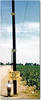
Location of maximum land subsidence in U.S. Levels at 1925 and 1977.

Detailed Description
Land subsidence in California - Approximate location of maximum subsidence in the United States identified by research efforts of Dr. Joseph F. Poland (pictured). Signs on pole show approximate altitude of land surface in 1925, 1955, and 1977. The site is in the San Joaquin Valley southwest of Mendota, California.
This photo shows the approximate location of maximum subsidence in the United States, identified by research efforts of Dr. Joseph F. Poland (pictured). The site is in the San Joaquin Valley southwest of Mendota, California. Signs on pole show approximate altitude of land surface in 1925, 1955, and 1977. The land surface subsided about 9 meters from 1925 to 1977 due to aquifer-system compaction.
The compaction of unconsolidated aquifer systems that can accompany excessive ground-water pumping is by far the single largest cause of subsidence. The overdraft of such aquifer systems has resulted in permanent subsidence and related ground failures. In aquifer systems that include semiconsolidated silt and clay layers (aquitards) of sufficient aggregate thickness, long-term groundwater-level declines can result in a vast one-time release of “water of compaction” from compacting aquitards, which manifests itself as land subsidence. Accompanying this release of water is a largely nonrecoverable reduction in the pore volume of the compacted aquitards, and thus a reduction in the total storage capacity of the aquifer system.
Find out more