Water Resources of the United States
Ten-year Anniversary of USGS Real-Time Streamflow Data on the Web
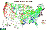
The USGS stream-gaging network provides important hydrologic information needed to manage our country's invaluable surface-water resources. Internet access to USGS real-time streamflow data was originally developed for public access in Montana. Requests for timely streamflow information in other parts of the country led to the development of a nationally seamless system which currently serves real-time data for more than 9,900 sites and services up to 19 million requests per month. Real-time streamflow data are processed and managed in the USGS National Water Information System (NWIS). NWISWeb, the web interface to NWIS, integrates many NWIS data, including real-time streamflow data, and provides the public with access to more than 100 years of water data collected by the USGS. Traditional NWISWeb users that have benefited from the timely and robust web-interface access to the USGS water data are engineers, scientists, water managers, and emergency response professionals. Internet access to USGS water data has also created a new class of external users including fishermen, floaters, landowners, and other individuals who otherwise would not be able to easily access these data in a timely manner. Access to real-time streamflow data aids in decreasing or preventing loss of life and property. More specifically, it is used to:
Links for more information about NWISWeb, streamflow data, and water in the United States include: U.S. Geological Survey Fact Sheet describing NWISWeb National streamflow information program |
![]() U.S. Department of the Interior |
U.S. Geological Survey
U.S. Department of the Interior |
U.S. Geological Survey
URL: https://water.usgs.gov/anniversary.html
[an error occurred while processing this directive]
Page Contact Information: (none)
Page Last Modified: Tuesday, 13-Dec-2016 08:05:17 EST
URL: https://water.usgs.gov/anniversary.html
Page Contact Information: NatWeb Team (GS_Help_Natweb@usgs.gov)
Page Last Modified: Tuesday, 13-Dec-2016 08:05:17 EST

 February
14, 2005 marks the ten-year anniversary of U.S. Geological Survey
(USGS) real-time streamflow data availability to the public on
the web (see
February
14, 2005 marks the ten-year anniversary of U.S. Geological Survey
(USGS) real-time streamflow data availability to the public on
the web (see